Dave Lesher
Tucker County’s first snowflakes of the season earlier this month is a reminder that that more of it will soon be on its way, our trademark for life here in the wintertime. In a good snowy winter, it comes in abundance to cover high elevations of Canaan Valley, bringing locals and visitors a chance to enjoy some of the best skiing in the East.
Until recently, snowy winters in Canaan had been the rule for many years. But in just the last few years, there’s been a growing feeling that a change is coming. Those who live here and those who come here to ski have sensed it and are probably not mistaken; winter snowfall amounts that the valley enjoyed a decade ago now seem gone away.
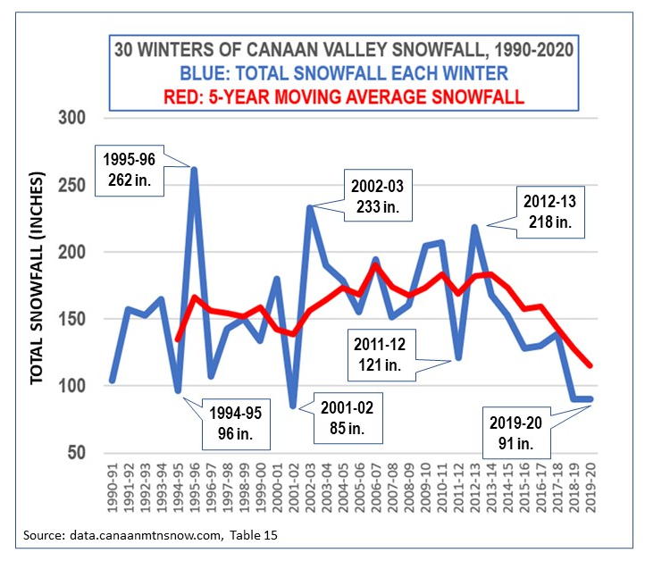
The accompanying chart contains two graphs that illustrate those changes. The blue line graph tracks the total snowfall for each of the last 30 winters as recorded at the National Weather Service weather station near Canaan Village in the center of the valley. The red line graph is the five-year moving average snowfall based on the individual winter amounts.
Several features of the chart are worth pointing out. The blue line graph shows that the string of 13 winters from 2002-03 to 2014-15 was a great stretch of years for snow lovers. All but one of those winters provided more than 150 inches of snow and four of them were over 200 inches. Then something happened. Five winters ago, 2015-16, Canaan’s snowfall dropped well short of 150 inches. And likewise the two winters that followed. After that, the bottom seems to have dropped out as the last two winters before now both came in at a trifling 90 inches each. For most anywhere else in the mid-Atlantic, 90 inches of snow in a winter would be considered plenty. Not Canaan Valley.
The other feature to point out is the red line graph of the 5-year moving average snowfall amounts. This type of graph is a plot of the average snowfall of five consecutive years, a simple way to smooth out trends in data that varies widely. From this graph we can see that the downward trend of Canaan snowfall actually began earlier than was apparent from the individual winter snowfall amounts; it began as far back as the winter of 2013-14. This is significant.
The foregoing is unmistakable evidence that a downturn in Canaan snowfall has been occurring for the past seven winters. That’s the easy part of this discussion because it’s based on data and facts. The hard part is put one’s finger on possible reasons why it’s happening. Since there are no clear data on that, any such answer would be what one might call educated opinion. This writer’s opinion is that Canaan snowfall is on decline because of several aspects of rising temperatures here as it is elsewhere on earth. There are two and perhaps more features of the role temperatures play that affect Canaan snowfall. One is fact that the sheer number of winter snowfall events will undergo a decrease as some of those events become partly or totally rain events. Another aspect of the effect of warming are the subtle changes to the global circulation which in turn alters some storm tracks just enough to make them less snow-makers than usual. There are likely other factors in play that may also influence snowfall patterns, but it seems they are all connected in some way to the warming underway at a global scale.
Having said all this, there is no expectation that Canaan snowfall will soon dwindle to nothing. Winters will still be cold here and moisture will still be wrung out of the atmosphere as air is forced up and over these highlands. As weather patterns stabilize in response to a warming climate, winter snowfall amounts will stabilize in what might be called a new normal. While there may not be quite as much snow as there used to be, there will almost always be more snow in Canaan than anywhere else in these mountains.


